
We are finding that it is common practice for governments of small and medium-sized towns to use their powers of annexation, zoning, provision of infrastructure and public services, long-term planning, and maximization of tax base to exclude minority and low-income communities from full participation in the town's benefits and governance. City boundaries are being selectively drawn to include new, wealthier subdivisions ("cherry picking") while keeping older, minority, and lower-income communities outside the boundaries. In this way, the governments are seeking to build a tax base at the expense of building a community. This practice may create minority "islands," surrounded by a town but excluded from participation. We have developed a program based on Geographical Information Systems (GIS) to aid minority and low-income communities which have been excluded from their local towns.
 | Community boundaries are often invisible. Who can drive down a road and know where water or sewer service - or city police protection - starts and stops? While the disparities are not readily visible to the community as a whole, property owners often know they are being treated inequitably. They just don't know the extent of the problem and are unable to vote for change because they are not residents of the town. |
Sewer Access in Southern Moore County
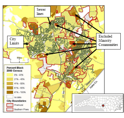
GIS maps have a unique power to illuminate this problem and begin the process of change. The GIS mapping process combines several types of information into a single picture. The base map is physical features (roads, city limits, county boundaries) onto which other variables (e.g. race, income, water service, etc.), can be added. Economic variables, such as average house value (from tax information) can also be illustrated. The power of GIS is this layering of different types of information onto a single map so that connections can be made (such as that between race and sewer access).
Needs Addressed
The newspapers are full of stories about county residents fighting annexation, but there is relatively little about neighborhoods who want to be annexed but are excluded from municipalities. Yet, there are communities throughout the nation that have repeatedly asked to be annexed and provided city services to no avail. Many of these are minority neighborhoods.
What does it mean to be excluded from one's town? Excluded communities often lack water and sewer service, have inadequate fire and police protection, are subject to zoning changes favoring non-residential use, have unpaved and/or closed roads, and experience declining land values ; all of which are significant obstacles to business growth and community development. If septic systems fail, and there is no sewer service available, then homes can be condemned. If water service is inadequate (i.e. system lines are too small), then fire protection is limited and fire insurance is more expensive. If ground water in wells is contaminated, health is at risk and housing value is reduced. In sum, property wealth can be gradually but permanently lost and quality of life is diminished.
Currently, towns are motivated almost solely by the economic need to increase their tax bases, which dictates exclusion of any low-income residents on town borders - especially minority neighborhoods, diluting the vote of the minority citizens inside the city limits. In addition, it is often the case that these boundary communities, while outside of town, are inside the town's Extra-Territorial Jurisdiction (ETJ). This allows the town to zone the properties to non-residential uses (which affects the long-term viability of a neighborhood and creates minority land-loss) and locate municipal facilities (e.g. landfills and sewer plants), while excluding these landowners from their decisions.
The most profound problem is that the exclusion from town denies the people of these communities the right to vote and thus hold local governments accountable. Learning how to use and map public records can enable minority and disadvantaged populations to make the case for municipal inclusion and to hold governments accountable for the delivery of services that meet basic human needs.
People in a community are well aware of the impact of being excluded from town boundaries, yet they often do not know the scope of the problem throughout an area and how many others are affected. Those who do realize a problem is systemic may not be able to prove this to others. The processes and language of local land policy are cloaked in jargon, buried in government meetings and documents, and hidden in legal frameworks that are complex and full of loopholes. There is relatively little oversight of local planning boards and commissions; often, the full minutes of meetings are either incomplete or difficult to access. These obstacles mean that even tenacious community groups and individuals may be unsuccessful in creating change. Yet, when problems become visible - when the map shows the big picture - things can begin to change.
Change is possible. Since our work in Moore County and in the town of Mebane has become public, the town of Mebane has procured sewer service for at least 10 homes, several of the excluded neighborhoods in Moore County have been annexed and others have received sewer service.
Populations Served
Our work serves minority neighborhoods which have been excluded from small and medium- sized towns due to the actions of town and county governments. Preliminary work (funded by the Warner and Z. Smith Reynolds Foundations) demonstrates that communities across North Carolina show this pattern. Our preliminary research also shows that this pattern occurs across the nation, with similar examples found in Zanesville, Ohio (As one resident of Zanesville, Ohio, graphically explained, "Where the white people stop, the water stops flowing." Columbus, Ohio; Orlando, Florida (where half of the residents in the Metro area can't vote due to exclusion); and Palm Beach, Florida.
Our analytical model can therefore be applied nationally, and that is our long-term goal.
Methods
Local and regional planning agencies have created large, public GIS files showing town boundaries, annexations, extraterritorial jurisdiction, zoning, roads, sewer and water lines, and other features in the community. This data can be combined with other public GIS data from the state agencies (Environment and Natural Resources, Department of Transportation, etc.) and federal agencies (U.S. Census, HUD, EPA) to map population characteristics, patterns of services, locations of facilities, locations of Superfund and other toxic sites, landfills, etc. This is key information for local community development organizations seeking support for development projects, demanding equitable decisions in locating highways and other public infrastructure, identifying under-served areas, and arguing for political inclusion. However, without awareness of the usefulness and power of public data, an understanding of how it can be accessed, and the methods and resources for mapping the data, public data is too often lost to the public good.
Our methods are straightforward. We acquire the data from the public agencies and make a map. We also conduct background research using primary sources (newspapers, interviews, tax records and public meeting records) to understand the context of the situation in the town, county, and community.
We work with communities which have identified a problem, and where community leaders exist to organize the residents and carry the work forward. These communities have been identified by a survey of the state conducted by us in 2003-2004 (funded by the Z. Smith Reynolds Foundation) and/or by various groups working with grassroots organizations, such as the North Carolina Fair Housing Center and the NC Justice & Community Development Center. Once we have made contact with the groups and individuals in the communities, we explore with them the issues of concern, show them the resources (public data) available to them, and provide the technical resources necessary to map their situations (such as access and proximity to water, sewer, toxic waste, evidence of exclusion, etc.).
Our goal is that, when we have completed a project in community, the agents for change in that community know what questions to ask, where to go for the information they need, and how to illustrate the community's problems, and that a dialog has been developed with the municipality in question to correct the local governments' past patterns of exclusion.
Promoting Long-Term Change
Maps are uniquely valuable tools in local community organizing because individuals can understand and relate to the larger patterns in the community. When we showed a map of Moore County showing the patterns of exclusion from municipal citizenship and denial of sewer services to a local activist, his response was, "So that's what they're doing!" A picture is truly worth 1,000 words, or more, in the case of the jargon and legalese that local governments use. Our work shines a light on hidden yet powerful processes by which local governments take land value from those who are excluded from voting for the governing bodies. In addition to preparing maps for local community groups, we teach people on-site about sources of data and about other sources for making the maps, so that they can then create their own maps in the future.